Friday, November 24

                                       Rajgir

Rajgir (originally known as Girivraj) is a city and a notified area in Nalanda district in the Indian state of Bihar. The city of Rajgir (ancient RājagṛhaPaliRājagaha was the first capital of the kingdom of Magadha, a state that would eventually evolve into the Mauryan Empire. Its date of origin is unknown, although ceramics dating to about 1000 BC have been found in the city. This area is also notable in Jainism and Buddhism[3] as one of the favorite places for Lord Mahavira and Gautama Buddha and the well known "Atanatiya" conference was held at Vulture's Peak mountain.
Rajgir is connected to Patna via Bakhtiarpur by rail and road. Bakhtiarpur lies midway between Patna and Mokameh. Road access is by NH 30A to Bakhtiarpur and NH 31 towards south to reach Bihar Sharif. From Mokameh NH 31 to Bihar Sharif. From there, NH 82 will leads to Rajgir. Rajgir is around 100 KM from both Patna and Mokameh. It is located in a green valley surrounded by rocky hills, Rajgir hills. A daily Indian Railways train Shramjeevi Express connects Rajgir with the Indian capital New Delhi.

History

The name Rajgir came from Rājagṛiha 'house of the king' or "royal house", or the word rajgir might have its origin in its plain literal meaning, "royal mountain". It was the ancient capital city of the Magadha kings until the 5th century BC when Udayin(460-440 BC), son of Ajatshatru, moved the capital to Pataliputra.[4] In those days, it was called Rajgrih, which translates as 'the home of Royalty'. Shishunaga founded Shishunaga dynasty in 413 BCE with Rajgir as its initial capital before it was moved to Pataliputra.
Rajgir is also famous for its association with Mauryan dynasty Kings Bimbisara and Ajatashatru. Ajatashatru kept his father Bimbsara in captivity here. The sources do not agree which of the Buddha's royal contemporaries, Bimbisara and Ajatashatru, was responsible for its construction. Ajatashatru is also credited with moving the capital to Pataliputra (modern Patna).
Buddha's cave, Griddhakuta Hill, Rajgir.
The epic Mahabharata calls it Girivraja and recount the story of its king, Jarasandha, and his battle with the Pandava brothers and their allies KrishnaJarasandha who hailed from this place, had been defeated by Krishna 17 times. The 18th time Krishna left the battlefield without fighting.[5] Because of this Krishna is also called 'ranachorh' (one who has left the battlefield). Mahabharata recounts a wrestling match between Bhima (one of the Pandavas) and Jarasandha, the then king of Magadha. Jarasandha was invincible as his body could rejoin any dismembered limbs. According to the legend, Bhim split Jarasandha into two and threw the two halves facing opposite to each other so that they could not join. There is a famous Jarasandha's Akhara (place where martial arts are practiced). It is also mentioned in Jain and Buddhist scriptures, which give a series of place-names, but without geographical context. The attempt to locate these places is based largely on reference to them and to other locations in the works of Chinese Buddhist pilgrims, particularly Faxian and Xuanzang. It is on the basis of Xuanzang in particular that the site is divided into Old and New Rajgir. The former lies within a valley and is surrounded by low-lying hills, Rajgir hills. It is defined by an earthen embankment (the Inner Fortification), with which is associated the Outer Fortification, a complex of cyclopean walls that runs (with large breaks) along the crest of the hills. New Rajgir is defined by another, larger, embankment outside the northern entrance of the valley and next to the modern town. It was here that Gautama Buddha spent several months meditating, and preaching at Gridhra-kuta, ('Hill of the Vultures'). He also delivered some of his famous sermons and initiated king Bimbisara of Magadha and countless others to Buddhism. On one of the hills is the Saptparni cave where the First Buddhist Council was held under the leadership of Maha Kassapa.
Son Bhandar Jain cave, Rajgir
It is sacred to the memory of the founders of both the religions: Jainism and Buddhism and associated with both the historical Mahavira and Buddha.
Lord Mahavira, 24th Tirthankara spent fourteen years of his life at Rajgir and Nalanda, spending Chaturmas (i.e. 4 months of the rainy season) at a single place in Rajgir (Rajgruhi) and the rest in the places in the vicinity. It was the capital of one of his Shravaks(follower) King Shrenik. Thus Rajgir is a very important religious place for Jains.The twentieth Jain tirthankara, Munisuvratais supposed to have been born here.An ancient temple(about 1200 years old) dedicated to Munisuvrat bhagwan is also present here along with many other jain temples.This temple is also a place for four Kalyanakas of Bhagwan Munisuvratnath.

Geography and climate

View of Rajgir hills from Jarasandha's Akhara
The city was in a valley surrounded by seven hills: Vaibhara, Ratna, Saila, Sona, Udaya, Chhatha, and Vipula.
Rajgir has also developed as a health and winter resort due to its warm water ponds. These baths are said to contain some medicinal properties that help in the cure of many skin diseases. .Another attraction of the region is the ropeway that leads uphill to the Vishwa Shanti Stupa (Peace Pagoda), Makhdoom Kund and monasteries built by Japanese devotees of the Buddha on top of the Ratnagiri Hills.
Temperature: maximum 44 °C, minimum 20 °C. Winter: maximum 28 °C, minimum 6 °C
Rainfall: 1,860 mm (mid-June to mid-September)
Dry/warm season: October to March

Notable places

Son Bhandar cave with 3-4 century AD Jain images and inscriptions[7]
The renowned Son Bhandar Caves is situated at Rajgir, Nalanda district in Bihar state. Son Bhandar group of caves has two caves known as eastern and western cave. Son bhandar caves are concerned with Jainism and considered to belong to 3-4 century AD.
These caves were first inspected by Cunninghum and he concluded to have analogy with Saptaparni Cave of Buddhism creed. After Cunninghum several scholars visited this place and some had opinion to concern with Buddhism. After some time all Buddhism connections were refused because of an inscription found on the southern wall of a cave.
According to this inscription these caves were built by inspiration of a Jain Muni Vair for Jain ascetics. Sculptures of Teerthankaras were also carved in these caves. From architectural aspect; these caves are analogous to Nagarjuni cave and Barabar Caves caves of Mauryanera. Therefore, it can be concluded that construction time should not be much differ from above mentioned caves.
These caves should be related to Digambar sect of Jainism as Xuanzang wrote in his book about Vaibhar Hill of Rajgir that the place was occupied by Digambar Jain monks for meditation purpose. After some centuries these caves were converted by Hindus as Lord Vishnu sculpture was also found from mound of a cave.[8]
Historically, Rajgir has been a very important place in Jainism, as capital to many empires. The main tourist attractions include the ancient city walls from Ajatshatru's period, the Bimbisar's Jail, Jarasandh's Akhara, Gridhra-kuta, ('Hill of the Vultures')Sonabhandaracave and the Jain temples on the five peaks.
Rajgir is famous for its hot water springs, locally known as Brahmakund, a sacred place for Hindus. Another major attraction is the peace pagodaVishwa Shanti Stupa, built in 1969, one of the 80 peace pagodas in the world, to spread the message of peace and non-violence. The rope-way that leads to it is another attraction.
The Japanese temple is beside the Venu Vana. Venu Vana is an artificial forest, where one can enjoy Eternal peace, and meditate.And famous Makhdoom KundSri Ramakrishna Math is a non-political spiritual organization which have been engaged in various forms of humanitarians, social service activities.
Bamboo Grove in Venu Vana.
Rajgir Heritage Museum is another place of Interest, recently inaugurated by CM Nitish Kumar.

Demographics

As of the 2011 India census, Rajgir had a population of 41,587 . Males constitute 53% of the population and females 47%. Rajgir has an average literacy rate of 52%, lower than the national average of 59.5%: male literacy is 61%, and female literacy is 41%. In Rajgir, 19% of the population is under 6 years of age.But now the literacy average of Rajgir is (increasing from 2007) about 70%.

Transportation

Bihar State Tourism Development Corporation provides travel facility from state capital Patna to visit Bodh circuit (Bodhgaya, Rajgir, NalandaVaishaliKesariaLumbiniKushinagarSarnath), Jain Circuit (Rajgir, Pawapuri) and Sikh Circuit in Bihar.

Sports

Nalanda International Cricket Stadium is a proposed cricket stadium in the city. In 2013, it was announced by the Chief Minister of BiharNitish Kumar that an international cricket stadium will be constructed at Rajgir in Bihar's Nalanda district.[12][13] After completion the stadium will home of Bihar cricket team.

                             Bodh Gaya

Bodh Gaya is a religious site and place of pilgrimage associated with the Mahabodhi Temple Complex in Gaya district in the Indianstate of Bihar. It is famous as it is the place where Gautama Buddha is said to have obtained Enlightenment (Pali: bodhi) under what became known as the Bodhi Tree.
For Buddhists, Bodh Gaya is the most important of the main four pilgrimage sites related to the life of Gautama Buddha, the other three being KushinagarLumbini, and Sarnath. In 2002, Mahabodhi Temple, located in Bodh Gaya, became a UNESCO World Heritage Site.

History

Bodh Gaya is the most holy place for Buddhists. Situated by the bank of river Neranjana the place was then known as Uruwela. King Ashoka was the first to build a temple here.
Traditionally, Buddha was born in 563 BC in what is now Nepal  on the following auspicious Baisakhi purnima. As Siddhartha, he renounced his family at the age of 29 in 534 BC  and travelled and meditated in search of truth. After practicing self-mortification for six years at Urubela (Buddhagaya) in Gaya, he gave up that practice because it did not give him Vimukthi. Then he discovered Noble Eight-fold path without help from anyone and practiced it, then he attained Buddhatva or enlightenment. Enlightenment is a state of being completely free from lust (raga), hatred (dosa) and delusion (moha). By gaining enlightenment, you enter Nibbana, in which the final stage is Parinibbana.
At this place, the Buddha was abandoned by the five men who had been his companions of earlier austerities. All they saw was an ordinary man; they mocked his well-nourished appearance. "Here comes the mendicant Gautama," they said, "who has turned away from asceticism. He is certainly not worth our respect." When they reminded him of his former vows, the Buddha replied, "Austerities only confuse the mind. In the exhaustion and mental stupor to which they lead, one can no longer understand the ordinary things of life, still less the truth that lies beyond the senses. I have given up extremes of either luxury or asceticism. I have discovered the Middle Way". This is the path which is neither easy (a rich prince) nor hard (living in austere conditions practicing self-denial). Hearing this, the five ascetics became the Buddha's first disciples in Deer Park, Sarnath, 13 km n.e. of Benares.
The disciples of Gautama Siddhartha began to visit the place during the full moon in the month of Vaisakh (April–May), as per the Hindu calendar. Over time, the place became known as Bodh Gaya, the day of enlightenment as Buddha Purnima, and the tree as the Bodhi Tree.
The history of Bodh Gaya is documented by many inscriptions and pilgrimage accounts. Foremost among these are the accounts of the Chinese pilgrims Faxian in the 5th century and Xuanzang in the 7th century. The area was at the heart of a Buddhist civilization for centuries, until it was conquered by Turkic armies in the 13th century. The place-name, Bodh Gaya, did not come into use until the 18th century CE. Historically, it was known as Uruvela, Sambodhi, Vajrasana or Mahabodhi.[9] The main monastery of Bodh Gaya used to be called the Bodhimanda-vihāra (Pali). Now it is called the Mahabodhi Temple.
Five bombs were detonated in Mahabodhi temple premises on 7 July 2013. 4 bombs were also detonated in town while three were defused.

Mahabodhi Temple

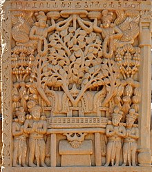
Illustration of the temple built by Asoka at Bodh-Gaya around the Bodhi tree. Sculpture of the Satavahanaperiod at Sanchi, 1st century CE.
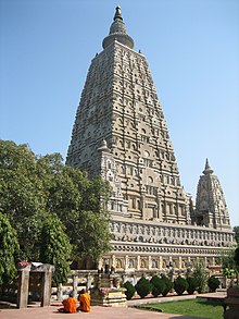
Mahabodhi temple, built under the Gupta Empire, 6th century CE.The complex, located about 110 kilometres from Patna, at 24°41′43″N 84°59′38″E, contains the Mahabodhi Temple with the diamond throne (called the Vajrasana) and the holy Bodhi tree. This tree was originally a sapling of the Sri Maha Bodhi tree in Sri Lanka, itself grown from a what is claimed to be a sapling of the original Bodhi tree.In approximately 250 BCE, about 200 years after the Buddha attained Enlightenment, BuddhistEmperor Asoka visited Bodh Gaya in order to establish a monastery and shrine on the holy site, which have today disappeared.


Representations of this early temple are found at Sanchi, on the toraṇas of Stūpa I, dating from around 25 BCE, and on a relief carving from the stupa railing at Bhārhut, from the early Shungaperiod (c. 185–c. 73 BCE). The present pyramidal temple was built at the time of the Gupta Empire, circa the 6th century CE.


Other Buddhist temples

Buddhist Man Meditating in Bodh Gaya
Kittisirimegha of Sri Lanka, a contemporary of Samudragupta, erected with the permission of Samudragupta, a Sanghārāma near the Mahabodhi Temple, chiefly for the use of the Singhalese monks who went to worship the Bodhi tree. The circumstances in connection with the Sanghārāma are given by Xuanzang (Beal, op. cit., 133ff) who gives a description of it as seen by himself. It was probably here that Buddhaghosa met the Elder Revata who persuaded him to come to Ceylon.
Several Buddhist temples and monasteries have been built by the people of BhutanChinaJapanMyanmarNepalSikkimSri LankaTaiwanThailandTibet and Vietnam in a wide area around the Mahabodhi Temple. These buildings reflect the architectural style, exterior and interior decoration of their respective countries. The statue of Buddha in the Chinese temple is 200 years old and was brought from China. Japan's Nippon temple is shaped like a pagoda. The Myanmar (Burmese) temple is also pagoda shaped and is reminiscent of Bagan. The Thai temple has a typical sloping, curved roof covered with golden tiles. Inside, the temple holds a massive bronze statue of Buddha. Next to the Thai temple is 25-metre statue of Buddha located within a garden which has existed there for over 100 years.

Niagara Fall

Niagara Fall

Niagara Falls
3Falls Niagara.jpg
LocationBorder of Ontario, Canada, and New York, United States
Coordinates43.0799°N 79.0747°W
TypeCataract
Total height167 ft (51 m)
Number of drops3
WatercourseNiagara River
Average
flow rate
85,000 cu ft/s (2,400 m3/s)
Niagara Falls (/nˈæɡrə/) is the collective name for three waterfalls that straddle the international border between Canada and the United States; more specifically, between the province of Ontario and New York state. They form the southern end of the Niagara Gorge.
From largest to smallest, the three waterfalls are the Horseshoe Falls, the American Falls and the Bridal Veil Falls. The Horseshoe Falls lies on the border of the United States and Canada[1] with the American Falls entirely on the United States' side, separated by Goat Island. The smaller Bridal Veil Falls are also on the United States' side, separated from the other waterfalls by Luna Island.
Located on the Niagara River, which drains Lake Erie into Lake Ontario, the combined falls form the highest flow rate of any waterfall in the world that has a vertical drop of more than 165 feet (50 m). During peak daytime tourist hours, more than six million cubic feet (168,000 m3) of water goes over the crest of the falls every minute.[2] Horseshoe Falls is the most powerful waterfall in North America, as measured by flow rate.
The falls are 17 miles (27 km) north-northwest of Buffalo, New York, and 75 miles (121 km) south-southeast of Toronto, between the twin cities of Niagara Falls, Ontario, and Niagara Falls, New York. Niagara Falls was formed when glaciers receded at the end of the Wisconsin glaciation (the last ice age), and water from the newly formed Great Lakes carved a path through the Niagara Escarpment en route to the Atlantic Ocean.
Niagara Falls is famed both for its beauty and as a valuable source of hydroelectric power. Balancing recreational, commercial, and industrial uses has been a challenge for the stewards of the falls since the 19th century.

Characteristics

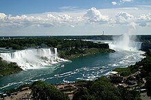
Canadian Horseshoe Falls as viewed from Skylon Tower
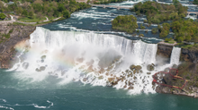
American Falls (large waterfall on the left) and Bridal Veil Falls (smaller waterfall on the right) as viewed from Skylon Tower
The Horseshoe Falls drop about 188 feet (57 m), while the height of the American Falls varies between 70 and 100 feet (21 and 30 m) because of the presence of giant boulders at its base. The larger Horseshoe Falls are about 2,600 feet (790 m) wide, while the American Falls are 1,060 feet (320 m) wide. The distance between the American extremity of the Niagara Falls and the Canadian extremity is 3,409 feet (1,039 m).
The peak flow over Horseshoe Falls was recorded at 225,000 cubic feet (6,400 m3) per second. The average annual flow rate is 85,000 cubic feet (2,400 m3) per second. Since the flow is a direct function of the Lake Erie water elevation, it typically peaks in late spring or early summer. During the summer months, at least 100,000 cubic feet (2,800 m3) per second of water traverses the falls, some 90% of which goes over the Horseshoe Falls, while the balance is diverted to hydroelectric facilities. This is accomplished by employing a weir – the International Control Dam – with movable gates upstream from the Horseshoe Falls. The falls' flow is further halved at night, and, during the low tourist season in the winter, remains a minimum of 50,000 cubic feet (1,400 m3) per second. Water diversion is regulated by the 1950 Niagara Treaty and is administered by the International Niagara Board of Control (IJC).
The verdant green colour of the water flowing over the Niagara Falls is a byproduct of the estimated 60 tonnes/minute of dissolved salts and "rock flour" (very finely ground rock) generated by the erosive force of the Niagara River itself. The current rate of erosion is approximately 1 foot (0.30 m) per year, down from a historical average of 3 feet (0.91 m) per year. It is estimated that 50,000 years from now, even at this reduced rate of erosion, the remaining 20 miles (32 km) to Lake Erie will have been undermined and the falls will cease to exist

Geology

The features that became Niagara Falls were created by the Wisconsin glaciation about 10,000 years ago. The same forces also created the North American Great Lakes and the Niagara River. All were dug by a continental ice sheet that drove through the area, deepening some river channels to form lakes, and damming others with debris.[9] Scientists argue there is an old valley, St David's Buried Gorge, buried by glacial drift, at the approximate location of the present Welland Canal.
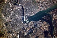
Aerial view of Niagara Falls, showing parts of Canada (left) and the United States (upper right)
When the ice melted, the upper Great Lakes emptied into the Niagara River, which followed the rearranged topography across the Niagara Escarpment. In time, the river cut a gorge through the north-facing cliff, or cuesta. Because of the interactions of three major rock formations, the rocky bed did not erode evenly. The top rock formation was composed of erosion-resistant limestone and Lockport dolostone. That hard layer of stone eroded more slowly than the underlying materials. The aerial photo on the right clearly shows the hard caprock, the Lockport Formation (Middle Silurian), which underlies the rapids above the falls, and approximately the upper third of the high gorge wall.

Vaishno Devi.....


Vaishno Devi, also known as Mata Rani, Trikuta and Vaishnavi, is a manifestation of the Hindu Mother Goddess of MahaKali, MahaSaraswati and MahaLakshmi. The words ""maa" and "mata" are commonly used in India for "mother", and thus are often used in connection with Vaishno Devi. Vaishno Devi Mandir is a Hindu temple dedicated to the Hindu Goddess, located in Katra at the Trikuta Mountains within the Indian state of Jammu and Kashmir. The Temple or Bhawan is 13.5 km from Katra and various modes of transportation are available from katra to Bhawan, including Ponies, Electric vehicles and paalkhis operated by 2 or 4 persons. Helicopter services are also available up to Sanjichhat, which is 9.5 km from Katra.
Vaishno Devi Mandir is a popular Hindu temple dedicated to the Hindu Goddess, located in the Trikuta Mountains in Jammu & KashmirIndia.

Holiday Gift Guide: Unique Finds for Everyone on Your List

  Holiday Gift Guide is all about finding unique and thoughtful presents that cater to different tastes and needs. Whether you’re shopping ...